The Marine Parks Authority (MPA) today released the Jervis Bay and Solitary Islands Marine Park final zoning plans which come into effect on 1 March.
Community consultation on the draft zoning plan had resulted in the MPA receiving 3064 public submissions for the Jervis Bay MP and a total of 6519 for the Solitary Islands MP – during the three month consultation period.
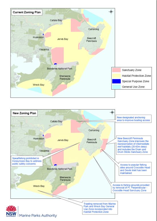
Initial impressions of the new zoning plan for the Jervis Bay Marine Park seem to suggest that the MPA has largely listened to submissions from the local community and anglers are set to benefit from improved access in some areas – an indication that the Fishing World-led savejb.com campaign was effective in sensibly voicing rec fishos’ concerns – in stark contrast to the nonsensical anti-fishing campaigns run by some green groups.
The MPA says ocean-based sanctuary zones in the Jervis Bay MP will be adjusted to better protect intermediate reef habitats. Commercial trawling will no longer occur at Wreck Bay or Crookhaven Bight and lift netting activities will be prohibited in Jervis Bay.
Under new zoning for the Solitary Islands prawn trawling will continue in a reduced area of the park and recreational fishing access will be improved at three key spots.
Key changes to the Jervis Bay Marine Park Zoning Plan:
- All trawling and lift netting will be removed from the marine park – 98 percent of submissions supported this proposal.
- The Point Perpendicular–Crocodile Head sanctuary zone will be replaced by a sanctuary zone off the Beecroft Peninsula – extending from Crocodile Head to Drum and Drum Sticks.
- Improved boating access to beaches in Hare Bay with a new anchoring area provided between Red Point and Hare Point.
- Spearfishing will be prohibited at Honeymoon Bay to address public safety concerns.
- Arrangements improved for the protection of species by simplifying restrictions and improving consistency with fisheries management rules (e.g. size and bag limits). Additional protection will be provided for some species, including Port Jackson Sharks, crested horn sharks and all skates and rays in the marine park.
- Zone boundaries “straightened” at Wreck Bay and Drum and Drum Sticks, which will make it easier for users to identify and comply with zones.
- Marine parks staff will also work with NSW Maritime to introduce new boating regulations in the park, including motorised boating restrictions in Honeymoon Bay, speed restrictions at Carama Creek, restrictions on irregular driving of personal watercraft within 200m of shore in Jervis Bay and a prohibition on motorised boats in Moona Moona Creek to protect seagrass beds.

Key changes to the Solitary Islands Marine Park Zoning Plan:
- Sanctuary zones will increase from 8,650 hectares (12% of park) to 14,000 hectares (19% of park), – 700 hectares less than the draft zoning plan. Importantly, the Central sanctuary zone includes additional intermediate reef habitat and the new Deepwater sanctuary includes, deep reef and deep soft sediment habitats, not included in the current plan.
- Recreational anglers and spearfishers will see improved access at key sites including Bare Bluff and South West Solitary (Groper) Island all year round, as well as an extra 500m at Minnie Water Back Beach and a section of reef at North West Rock.
- Prawn trawling will not be prohibited in the park within two years as proposed in the draft. An important fishing ground for trawling near North Solitary Island and key whiting grounds closer to shore will remain accessible. The area of general use zones where trawling can occur will be reduced to 13% of the park to further reduce ecological impacts of trawling. A package of initiatives to monitor ecological impacts and the sustainability of trawling in the future including mandatory use of GPS vessel monitoring systems is also being developed, consistent with the Ocean Trawl Fishery Management Strategy and environmental impact assessment.
- Three new Aboriginal Special Purpose Zones at the Corindi River, Corindi Rock Platform and Red Rock Beach. Recreational fishing will continue unaffected in these new zones and elders will work closely with the Marine Parks Authority on the management of these areas.
- Commercial beach haulers will benefit from increased access on beaches at Arrawarra and Sandy Beach, and changed access at Station Creek Beach.
- Straight line boundaries as opposed to the previous rounded boundaries, to make it easier for users to identify and comply with zones.
- Several species added to the list prohibited to be taken from the park; and the grey nurse shark better protected through closures implemented by Industry & Investment NSW at North and South Solitary Islands.
- The Environmental Trust will provide funding of up to $400,000 to Industry & Investment NSW to administer a voluntary commercial fishing buy out to avoid commercial fishing pressure increasing elsewhere.

Detailed information on the new zoning plans are on the marine parks website at www.mpa.nsw.gov.au. Jervis Bay Marine Park changes can be found at http://mpa.nsw.gov.au/jbmp-zoning-plan-2011.html.
The MPA says it expects to hold community information sessions at key locations in coming weeks. Details of these sessions will be posted on the marine parks website.
Fisho will be analysing these new marine park zonings more thoroughly in coming days and will let you know what the changes will mean for rec fishos.